-
Share this page
WALOUS project
Wallonie Occupation Utilisation du Sol
Website: https://geoportail.wallonie.be/walous
Researcher(s):- Moritz Lennert
- Taïs GRIPPA
- Sabine Vanhuysse
Description
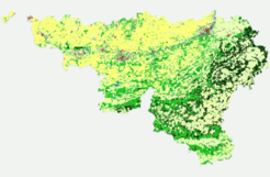
The WALOUS research project resulted in the creation of the new official land use and land cover maps of the Walloon administration for the year 2018. These maps allowed the Walloon region to become the first European region to produce land cover maps at 1m resolution. These cartographic products are obviously compatible with the European directive INSPIRE.
In the "land cover" part, ANAGEO was responsible for the automated VHR OBIA classification of nearly 17.000km² with data at 25cm spatial resolution. The management of such a large amount of data (Big-data) was possible thanks to the automation of the image segmentation by means of unsupervised processes, but also the high parallelization of the processing on high performance computing infrastructures. The team was also in charge of the fusion of pixel-oriented and object-oriented classifications.
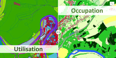
In the land use part, ANAGEO was responsible for the production of the automated processing chain while ISSEP was in charge of the co-creation of the legend and the technical specifications with the users. The map was produced by combining about 20 existing geodatabases, using a system of decision rules.
These maps are the result of a co-construction process with a panel of Walloon users. The maps provide the Walloon administration and the many interested actors with reference tools to better understand and manage the territory.
Thanks to the Storymap of the project (interactive, cartographic and multimedia web content), discover the main principles of WALOUS and easily distinguish between occupation and land use.
The maps produced as well as the processing chains are documented and available under open-source license.
This project was conducted in partnership with UCLouvain and ISSEP with whom ULB has strong links for several years.
Period
2018 - 2020
Partners
Earth and Life Institute | UCLouvain - Website
Remote Sensing and Geodata Unit | Institut Scientifique de Service Public (ISSeP) - Website
Funding
Research funded by the Public Service of Wallonia (PSW).